Choose Chatan for the easiest first Okinawa cycling day, Kaichu Road when the east-coast ride itself is the point, and Kouri Island only when your northern itinerary already puts you close enough to enjoy the circuit rather than commute to it. The famous view is not the hard part. Wind on the return, hills, heat, bike pickup and the trip back to your hotel decide whether the ride still feels worthwhile after the photo stop.
If the wider trip is not fixed, compare the 5-day Okinawa self-drive itinerary with the Naha 2-day no-car itinerary first. Cycling should fit the base you already need; I would not add a hotel move or an extra rental-car day just to make one bike route work.
ValueNavi decision table: which route solves your actual problem?
↔ Scroll table left or right
Route | Best when | Hidden cost | When I would skip it |
Chatan coast | You want a forgiving half-day, cafés and easy bailout points | Less of a destination ride; part of the value comes from convenience | You already have a stronger coastal ride elsewhere in the trip |
Kaichu Road | The east coast, Hamahiga/Henza/Ikei area is already your day | Exposed wind can make the return much harder than the outward leg | You are crossing the island only for the bike ride |
Kouri Island | You are already staying or sightseeing around Nago, Motobu or Nakijin | Bridge wind, island hills and bike availability make the 8 km circuit more than an 8 km number | You are coming from Naha solely to cycle and then returning south |
The decision rule is simple: the route should remove transport friction from the day, not create more of it. A less famous coastal ride beside your hotel can be the better Okinawa cycling experience if it gives you two relaxed hours instead of a half-day of driving, pickup and return logistics.
True time cost: count hotel-to-hotel, not just kilometres ridden
For each route, calculate five blocks: getting to the bike, pickup and setup, the actual ride, stops and food, then the return to the hotel or car. That is the useful time cost. A short route can still consume half a day if the bike is far from your accommodation; a three-hour model course can fit neatly if the rental point is already inside your northern route.
This is why raw distance is a weak comparison. A 5 km exposed road with a headwind can feel more demanding than a hillier e-bike circuit, while a compact urban-coast ride can be shortened the moment heat, rain or a tired child changes the plan.
Chatan is the best first ride when flexibility matters
Chatan gives a first-time rider more cafés, developed streets and easy stopping points. It is a better place to learn how Okinawa heat and coastal wind feel before committing to a long bridge or island circuit. If the group is mixed—one confident rider and one person who has not cycled for years—this is the route I would choose first because turning around early does not destroy the day.
If Naha remains the main base, use Do You Need a Car in Okinawa? to decide whether the bike day should replace a rental-car day, then compare the Okinawa car-rental guide and keep the rainy-day and typhoon backup ready.
Kaichu Road is mainly a wind-and-return decision
Kaichu-doro runs for roughly 5 km toward Henza Island, with possible extensions toward nearby islands. The exposed sea-road setting is the attraction, but it also means the return can feel very different from the outbound ride. Set a turnaround point before you start and do not spend all your energy chasing one more island because the first half felt easy.
If Kaichu Road is already part of a self-drive day, cycling can replace a portion of the driving and make the coast itself the experience. If you are staying on the west coast and would cross Okinawa only to ride there, the transport burden can outweigh the cycling gain. That is the boundary condition that changes my recommendation.
If a weather-sensitive coastal day is not appealing, compare it with Blue Cave snorkeling or a Kerama Islands activity day. If the question is broader than cycling versus water, use the Okinawa activities guide to compare a full day by transport burden and weather sensitivity.
Kouri Island works best when the northern stay already makes sense
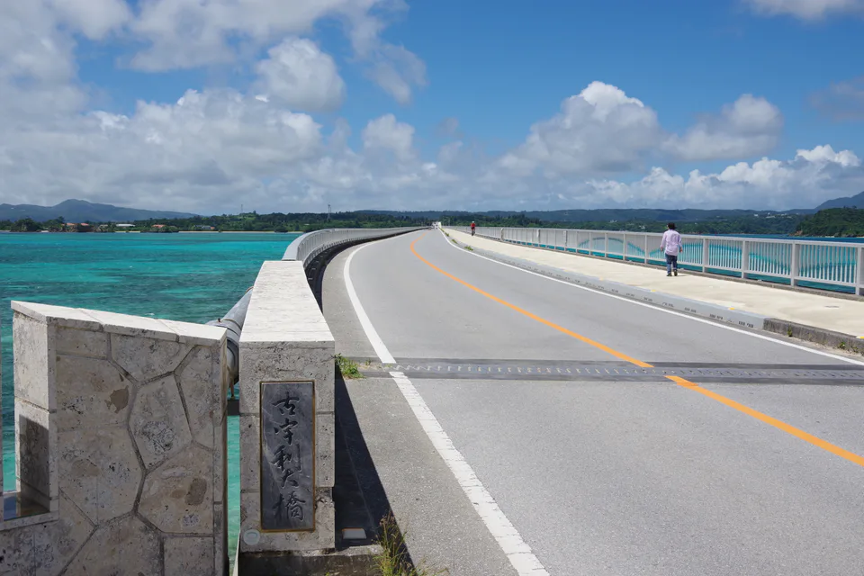
GREEN RIDE OKINAWA’s current official model course describes Kouri Island as about 8 km around, with the Kouri Bridge measuring 2,020 m, and builds an electric-assist sightseeing circuit of about three hours. Those numbers are useful because they show the difference between “cross the bridge for a photo” and “make the island the activity.” The model route includes stops rather than treating the island as an uninterrupted fitness ride.
The hidden cost is getting there. If Kouri and Churaumi are already the northern focus, the bike ride can slot naturally between a northern hotel and the rest of the day. If you are starting from Naha, the same three-hour ride sits inside a much larger transport commitment. Compare The Orion Hotel Motobu vs Ala Mahaina before choosing a base; hotel geography can decide whether the cycling day begins with a simple ride or another long transfer.
Route-conflict matrix: what can share the same day?
↔ Scroll table left or right
Combination | Fit | Why |
Chatan ride + American Village / central-Okinawa dinner | Strong | Same-area day; the ride can expand or shrink without breaking a timed attraction |
Kaichu Road ride + Hamahiga / Henza / Ikei self-drive | Strong if weather is stable | The bike route replaces part of an east-coast driving day instead of adding a new transfer |
Kouri circuit + one northern anchor | Good | A three-hour sightseeing ride still leaves room for one major northern stop |
Kouri circuit + Churaumi + Bise + Nakijin + long drive back to Naha | Poor | The cycling is no longer the problem; repeated stops and the final southbound drive are |
The usual failure mode is treating cycling as “free” because it replaces a short drive on the map. Once changing, rental setup, photo stops and the return are counted, the bike needs a real slot in the day. If the rest of the itinerary only works when every stop runs perfectly, remove one stop before shortening the cycling route into a rushed photo exercise.
Check the actual rental point, return method and battery on the travel day
Okinawa has current app-based e-bike and cycling services, but station inventory and return availability can change. Confirm the bike, return method, helmet and battery before committing to a long route. Do not assume an e-bike removes every hill or wind problem: assistance helps effort, but it does not make a crosswind disappear or guarantee the battery you expected is available.
For map changes, rental messages and a route that may move away from central Naha, keep the Okinawa eSIM guide in the same planning chain. If the hotel is the start point, compare an Onna-area stay such as HIYORI Ocean Resort Okinawa with a Naha base such as HOTEL COLLECTIVE.
Weather should shorten the route before it ruins the day
Start early in hotter months, keep water available and shorten exposed sections when wind or rain increases. The key mistake is using the pleasant outward leg as proof that the return will be equally easy. On exposed bridges and causeways, a change in wind direction can reverse the effort.
If the cycling window disappears, switch to the Okinawa rainy-day plan rather than driving across the island to search for another exposed route. A weather backup should reduce risk, not move the same risk to a different coast.
Final verdict: choose the route that still works on the return
Start with Chatan when flexibility matters, choose Kaichu Road when the east coast is already the day, and choose Kouri when the northern itinerary and an e-bike or stronger cycling experience make the island circuit realistic. I would not rank Kouri first merely because the bridge is more famous: from a Naha base, the transport tax can erase its advantage; from Motobu or Nakijin, the answer can reverse completely.
The best Okinawa cycling route is the one whose return leg, hotel location and weather risk still make sense after the sightseeing stops are added. If the route only looks good before you count getting there and getting back, it is the wrong route for that itinerary.
Pair this with
Pair the route decision with the 5-day self-drive route and the car-rental guide. If water activities are the main purpose of Okinawa, compare Kerama discovery diving. If the choice changes the number of rental-car days or hotel nights, check the Okinawa five-day cost guide before calling the cycling day the cheaper option.
Naoshima E-Bike Guide: Rental, Art Island Route and Ferry Timing
Okinawa Travel Guide: First-Time Itinerary, Hotels and Transport
Japan January Weather: What to Wear in Tokyo, Sapporo and Okinawa